The Moll collection is the main set of antique maps and vedute in the MZK, but certainly not the only one. Other important ensembles include the Schram Collection of Vedute and Portraits, the Old Print Collection, the Collection of Old Maps, the Collection of Maps from the 19th and 20 Centuries, and apart from that, a number of maps bound as supplements to books.
Other Stocks
-
The Schram Collection
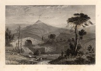
The beginnings of the Schram Collection date back to the second half of the 19th century. Originally randomly obtained graphics of the Francis Museum (now Moravské zemské muzeum) were, thanks to museum curator Moritz Trapp and later librarian Wilhelm Schram, assembled in the museum library and divided into two thematic units. The first focused on vedute of Brno and later on extended to the whole of Moravia. The collection's founders intended to gather visual documentation for each Moravian town. In the inter-war period the set was extended by Bedřich Václavek with more recent documentation. The second part consists of portraits (mainly lithographies) of personalities from the social and political life of Moravia, and partially also Vienna. The entire Schram Collection has been registered into the electronic catalogue and digitised.
The collection may be accessed using the shelfmark index of the historical resources catalogue (Schram Collection of Vedute – shelfmarks beginning with "Skř.1-0091.416; Schram Collection of Portraits - shelfmarks beginning with " Skř.2J "," Skř.2K "and" Skř.2L"). -
Graphic Collection
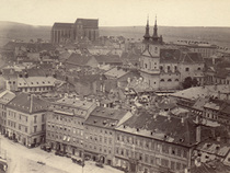
Apart from the coherent Schram Collection, the MZK owns a collection containing many other graphics and photographs, extended until today with documents created before 1920. This heterogeneous collection also contains a range of so-called "Moravicum", e.g. a large set of photos of Brno called "Bruna antiqua."
It may be searched in using the shelfmark index of the catalogue of historical stocks (shelfmarks beginning with 'Skř', except those listed in the Schram Collection index). A substantial part of the collection has recently been digitised as part of the Europeana Travel project. -
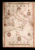
Collection of Old Maps
This is a collection of antique maps issued before 1850, created primarily by delimitations within the library. The entire collection of antique maps was registered in the electronic library catalogue and to a greater extent has also been digitized.
You may search within the collection using the shelfmark index of the catalogue of old prints (shelfmarks beginning with "STMpa"). A substantial part of the collection has recently been digitised as part of the Europeana Travel project. -
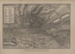
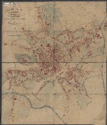
Collection of Maps from the 19th and 20th Centuries
The Collection of Maps from the 19th and 20th centuries is an open stock serving the storage of contemporary map production from the second half of the 19th century onwards. Unfortunately, the collection is largely available only through the original card catalogue. Gradual conversion into an electronic catalogue is under way. Maps are available in digital library Kramerius.
-
Atlases
From the very beginnings of the museum library, which was the foundation for today's MZK, its stocks included atlases. Sometimes they were even the original collector atlases - initially separate maps that the owners had bound on their own. This practice, however, completely subsided by the mid-19th century and gave way to published atlases, i.e. works that have been distributed as a whole.
The Moravská zemská knihovna owns both, works of cosmography from the 16th century that preceded atlases, as well as a representative set of 18th to 20th century atlas production. These are mostly different editions of atlases from the Homann family workshop, the younger Schraembl's atlas but also, for example, a maritime manuscript atlas, which is among the most beautiful cimelies in the whole of the MZK stock. Unfortunately, we do not have a satisfactory way of evidencing atlas works of the 19th and the first half of the 20th century and have to make do with the old system of catalogue cards for the time being. Some of the atlases have been digitized in recent years as part of the Europeana Travel project.
An overview of atlases that have already been digitised can be found here. -
Maps as Supplements to Books
A number of maps were bound as supplements to books. There is a basic system of inventory for such works for old prints published prior to 1800. Thorough processing, however, still awaits and as such searching through these works is not yet possible.
-
Wall Maps
In the library stock you may find a small set of wall maps that have been completely registered into the library catalogue. Their shelfmark begins with the letters "MPR"; their listing is therefore easily accessible via the index in the library catalogue.
